Hopeful faces turned westward more than 150 years ago as the greatest pioneer movement in history began along the Oregon Trail. Although the people who followed the trail started from many points along the Missouri River, historians place the true beginning of the trail in Independence, Missouri, at the southwest corner of Courthouse Square.
You can still find it there, surrounded by city. You can also steep yourself in trail lore at the National Frontier Trail Center in Independence, and stock up on reading material at the Oregon-California Trails Association headquarters next door.
From Courthouse Square, one branch of the Oregon Trail went south down Liberty Street and along the Blue Ridge, following the trace marked by Santa Fe traders since the 1820s. A different route went west on Lexington Street, heading toward Westport, which is now in Kansas City, Missouri.
“Independence is a handsome flourishing town with a high situation, three miles from the Missouri River on the South side and Surrounded by one of the most beautiful & Fertile countries of any Town in the Nation. Emigrants were encamped in every direction for miles around the place awaiting the time to come for their departure. Such were the crowded conditions of the Streets of [Independence] by long trains of Ox teams mule teams men there with stock for Sale and men there to purchase stock that it was all most impossible to pass along.”
—James A. Pritchard, April 22, 1849
From Independence the south route crossed the Blue River about 15 miles to the west. One popular camping place was at Lone Elm, south of Olathe, Kansas.
“About sundown we reached a small creek known as Elm Grove, and encamped. Timber proved quite scarce in this vicinity, and it was with great difficulty we procured sufficient for cooking.”
— Rufus B. Sage, 1841
Peter H. Burnett in May 1843 said the camping spot had two elm trees and a few dogwood bushes. “The small elm was most beautiful in the wild and lonely prairie; and the large one had all its branches trimmed off for firewood.”
By May 1846 when Virgil Pringle camped at Lone Elm, he wrote, “encamped at the lone tree, no wood but green willows.”
At Trail Junction, the Santa Fe continued southwest while the Oregon Trail turned northwest in a line roughly parallel to the Wakarusa River and then the Kansas or Kaw River.
The first real test of stamina, determination and endurance came in Nebraska where the trail entered a stagnant, disease-filled stream called Rock Creek.
Today, tall grasses and short bushes at Nebraska’s Rock Creek Station State Historic Park mark Oregon Trail ruts that are 50 to 60 feet wide and five to six feet deep. From 1841 to 1866, wagons passing Rock Creek ground the clay surface into talcumlike dust; erosion created the ruts.
Built by Newton Glenn in 1856 and purchased by David C. McCanles three years later, Rock Creek Station was one of the most important sites in what became Nebraska, serving not only Oregon Trail traffic, but also the folks headed west on the California Trail and Pony Express riders.
Besides its notoriety as a way station along the Oregon Trail, Rock Creek Station received attention in July 1861 when James Butler Hickok killed David McCanles over a disputed payment from the Pony Express. Though Hickok was charged with murder, he pleaded self-defense and was acquitted.
Buildings in use during the trail era have been carefully rebuilt on their original foundations, so Rock Creek Station appears today much as it did when covered wagons rolled past or camped along the creek.
As emigrants crossed the Kansas and Nebraska prairie, many died of accidents and disease. Asiatic cholera was the main killer in Nebraska, brought on when people drank stagnant, contaminated water. Though the trail followed the Little Blue and then the Platte Rivers, the water moved slowly and was a breeding ground for bacteria. Dysentery and cholera caused sudden, profuse diarrhea that led to rapid dehydration and often death.
It’s said that by 1850 there were four graves to the mile between St. Joseph, Missouri, one of the main jumping off points for trail travelers, and Fort Laramie.
The trek from the Little Blue to the Platte River—about 50 miles—was the longest distance in Nebraska the Oregon-bound travelers were without water; however, there were far longer stretches between sources of clean water.
In June 1852, 34-year-old Susan Hail is said to have drunk from a spring poisoned by Indians and died. It’s more probable the Indians didn’t poison the water, but that it was polluted by emigrants or their animals. Hail’s husband walked back to St. Joe, bought a tombstone and wheelbarrow, then pushed them to her grave northwest of Kenesaw and erected the tombstone on the freshly dug dirt.
Fort Kearny, located on bottomland south of the Platte near the upper end of Grand Island, was the first fort built specifically to protect travelers on the Oregon Trail. It was garrisoned from 1848 to 1871.
At Fort Kearny travelers could rest—or recruit as they called it—and obtain supplies. They had one of their best opportunities on the trail to send word home. “We arrived at Fort Kearny after noon. Here we had an opportunity of sending letters to our friends,” Joshua D. Breyfogle wrote on May 8, 1849. “The officers are going to send mail to the States in the morning and kindly offered to transmit any letter we wished to send.”
Should you wish to rest in the area today, you may not only visit the re-created Fort Kearny grounds, a Nebraska State Park, but you can also experience all the types of travel through this region at the Archway Monument, a massive structure spanning the four lanes of Interstate 80. Archway Monument takes you along the Great Platte River Road with films and vignettes about Indians and buffalo, the days of wagon travel and the development of the Lincoln Highway (U.S. 30) and Interstate 80. The exhibits allow you not only to see images but also to hear realistic sounds and even feel thunder. Adding to the experience, re-enactors in the lobby tell trail stories.
The land for Fort Kearny was obtained from the Pawnee Indians for $2,000 in trade goods, though the Indians reserved their hunting rights. Although the fort was never attacked, skirmishes between soldiers and Indians took place in the vicinity.
There were few assaults on emigrant wagon trains in the early years of trail travel, but on August 7, 1864, Indians attacked travelers near Plum Creek Station, some 36 miles west of Fort Kearny, killing several emigrants. A telegraph sent in response asked for “help as fast as God can send it.” The uprising, part of the general unrest on the Plains in 1864 and ’65, was less directed at Oregon-bound emigrants than people settling on the plains or headed to Colorado’s goldfields.
Like a braided stream, many emigrant roads came into Fort Kearny from the East, but to the West, there was just one main path to Oregon.
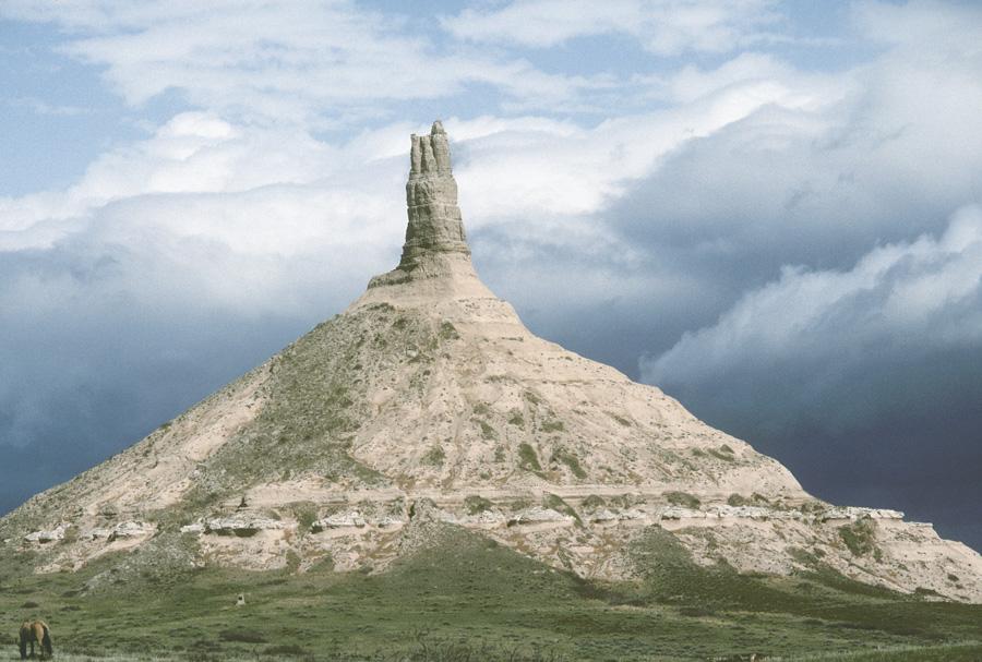
Trail ruts are more visible in Western Nebraska where the land hasn’t been turned by the plow. Near North Platte the terrain and vegetation begins to change. It’s drier; there are more hills, and eventually you’ll see cedars and prickly pear.
One story about the trail says people didn’t need a guide; they could follow the route by the smell of dead animals. By 1858, “the traveler could find his way with no other compass to guide than his nose alone,” traveler Kirk Knox wrote. Today when you’re driving west of North Platte, your own nose will constrict at the smell of beef feedlots. Imagine that in addition to the odor of cattle refuse, you could also catch a whiff of dead and decaying mules, horses, oxen and bison. That should give you an idea of the stench of the Oregon Trail.
West of Ogallala, which did not exist during trail days, the North Platte River—which the emigrants followed—is cut by the Kingsley Dam, its backwater forming Lake McConnaughy. The Nebraska sandhills stretch north, and the countryside changes from flat farmland to rolling hills and cattle ranches. When modern wagons pass over the trail, they still sink deeply into the sandy soil.
Near the head of Ash Hollow upstream from McConnaughy, travelers faced Windlass Hill. Crossing the prairie had been easy until this point, where the travelers had to descend a 300-foot hill with a 25-degree slope. It was the first steep hill emigrants had encountered, and it made a profound impact on them and the land. They rough-locked the wheels of the wagons with chains to keep them from turning and then slid to the bottom of the hill. The process cut deeply into the hillside, tearing away vegetation. Subsequent erosion has left the hill with deep, visible scars.
“Here we were obliged, from the steepness of the road, to let the wagons down by ropes, but the labor of a dozen men for a few days would make a descent easy and safe. The bottom of Ash Creek is tolerably well wooded, principally of ash and some dwarf cedars—traces of the great tide of emigration—plainly visible in remains of camp fires, in blazed trees covered with innumerable names—total absence of all herbage.”
— Howard Stansbury, July 3, 1852
It’s unclear why the landmark is called Windlass Hill, and there is no evidence the emigrants employed a windlass to lower the wagons. If such a contraption came into use, it was after 1866, according to Merrill Mattes writing in The Great Platte River Road.
The deep washes at Windlass Hill offer evidence of the passing of the pioneers. From there the trail dropped into Ash Hollow where fine ash trees line the hillsides. The presence of good water was welcome relief as the North Fork of the Nebraska River cut through the bottom of the hollow and there was also a cold, crystal clear spring. One traveler wrote of the miles before reaching Ash Hollow: “so much sickness and no good water.”
One of the few marked graves along the trail belongs to Rachel Pattison, who died of cholera near Ash Hollow on June 19, 1849. “Rachel taken sick in the morning, died that night,” Nathan Pattison recorded in his diary.
From 1843 until 1854 there was little conflict between the Oregon-bound travelers and the Indians who lived on land through which the trail passed. But in 1854 near Fort Laramie, an incident with a cow belonging to some Mormon emigrants led to a fight wherein the Sioux warriors killed Lieutenant John Grattan and his entire command. A year later near Ash Hollow, Colonel W. S. Harney retaliated against a different band of Sioux in the Battle of Blue Water or the Harney Massacre.
The increased travel over the Oregon road (eclipsed by the numbers of people headed to Utah over the Mormon Trail after 1847 and to California on the California Trail after 1849) displaced the Indians and native animals, making it hard for the tribes to feed themselves. As Shoshone Chief Washakie noted, “Since the white man has made a road across our land and killed off our game, we are hungry, and there is nothing for us to eat. Our women and children cry for food, and we have no food to give them.”
The Shoshones called the Oregon Trail the “River of Destruction.” The Lakotas called it “Wasicu Canku: White Man Road” initially, but after 1851, when they signed the treaty at Horse Creek, allowing travelers to freely cross the region, they referred to it as the “Holy Road,” perhaps, some have suggested, because the emigrants and military acted as though they had a God-given right to cross the land. For the tribes, the trail held a certain power—a spirituality tied to the land itself—that came from their concept that the land was a living thing, possessing a soul, thus the term “Holy Road.”
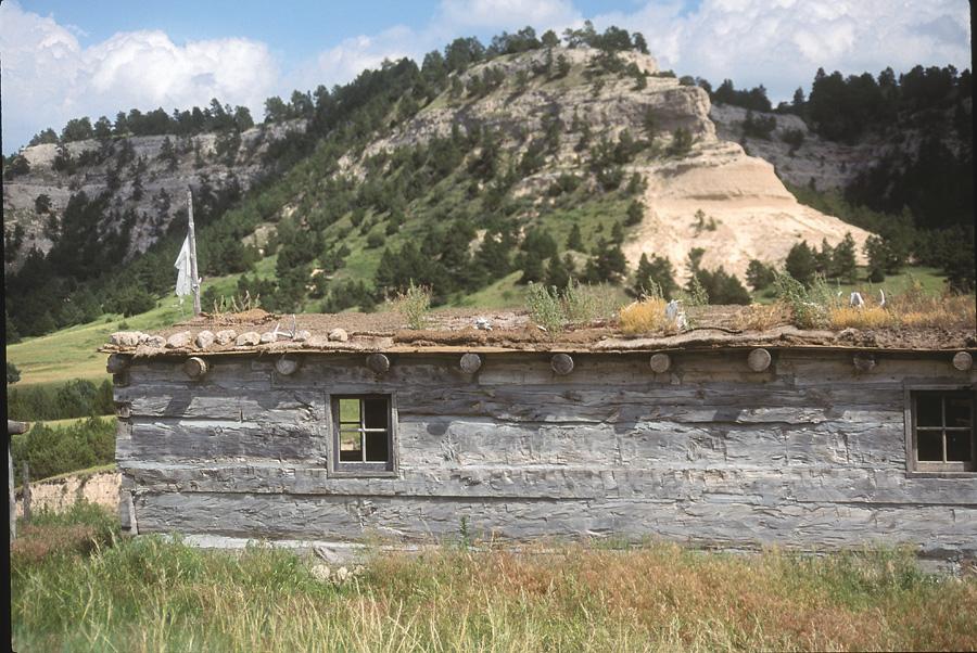
Beyond Ash Hollow, massive rock formations such as Courthouse Rock, Chimney Rock and Scotts Bluff stood in stark contrast to the rolling plains. Acting like guiding beacons, these monoliths drew the emigrants ever Westward toward the new life that awaited them in Oregon.
Candy Moulton would rather be on the trail than sitting in front of a computer. Lucky for her, she’s been able to travel the Oregon Trail by car, foot and wagon across portions of Missouri, Kansas, Nebraska, Wyoming, Idaho and Oregon. And she lived to tell about it in Wagon Wheels: A Contemporary Journey on the Oregon Trail.
Photo Gallery
– Author’s Collection –
– Photo By Karen A. Robertson –
Related Articles
-
Many people dream of leaving the hustle and bustle of everyday life, moving off the…
-
In the last decade, with the bicentennial of the Lewis and Clark Corps of Discovery…
-

“Should any of my readers ever be impelled to visit the prairies…I can assure him…