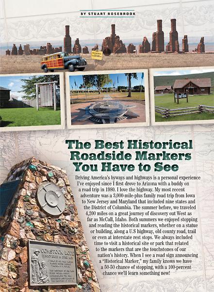
 Driving America’s byways and highways is a personal experience I’ve enjoyed since I first drove to Arizona with a buddy on a road trip in 1980. I love the highway.
My most recent adventure was a 3,000-mile-plus family road trip from Iowa to New Jersey and Maryland that included nine states and the District of Columbia. The summer before, we traveled 4,200 miles on a great journey of discovery out West as far as McCall, Idaho. Both summers we enjoyed stopping and reading the historical markers, whether on a statue or building, along a U.S highway, old county road, trail or even at interstate rest stops. We always included time to visit a historical site or park that related to the markers that are the touchstones of our nation’s history. When I see a road sign announcing a “Historical Marker,” my family knows we have a 50-50 chance of stopping, with a 100-percent chance we’ll learn something new!
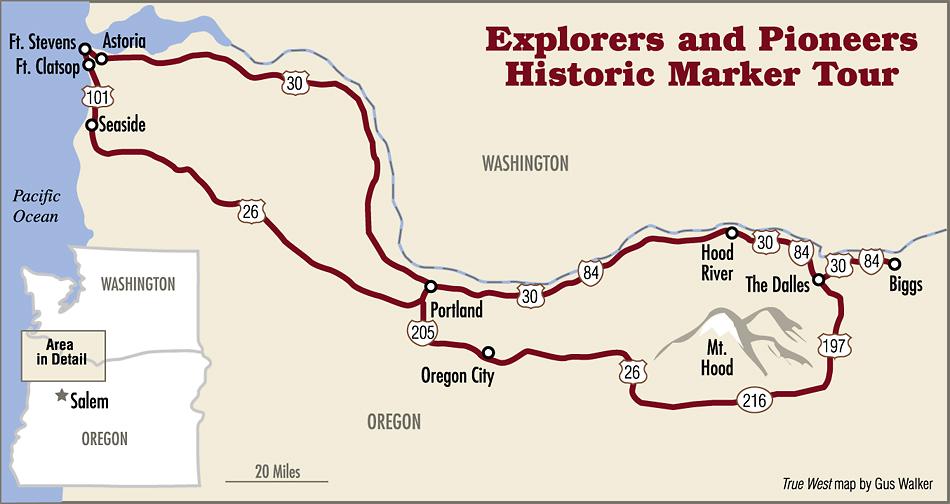
Oregon Trail Explorers and Pioneers Historical Markers
Joseph L. Meek trapped beaver across the West for 12 years before he made Oregon his home near the historical marker “Joseph L. Meek,” 1.5 miles east of North Plains on U.S. Highway 26. In 1840, he helped lead the first wagon over the Oregon Trail. The future first marshal of the territory was “very popular and as brave as Julius Caesar.”
Begin your coastal tour at a historical marker on U.S. 101 north of Cannon Beach, which tells the story of William Clark trading for whale blubber and supplies with the local Indians. In Seaside, you should visit the Seaside Museum and Historical Society before touring nearby Fort Clatsop National Historic Park, the winter home of the Corps of Discovery in 1805-1806. Originally constructed in 1863 to guard the mouth of the Columbia River, Fort Stevens, a state park and military museum, is the last stop on the coastal highway. Don’t miss historical markers for both forts on U.S. 101.
Nearby Astoria is home to the outstanding Oregon Maritime Museum. Enjoy the view from Astoria Tower, a sentinel of history in a park above the town. From Astoria, U.S. 30 follows the Columbia River to Portland. Pick up I-84 to Troutdale and two historical markers: “Troutdale,” on the way into town, and “Sandy River Bridge,” at Lewis and Clark State Park.
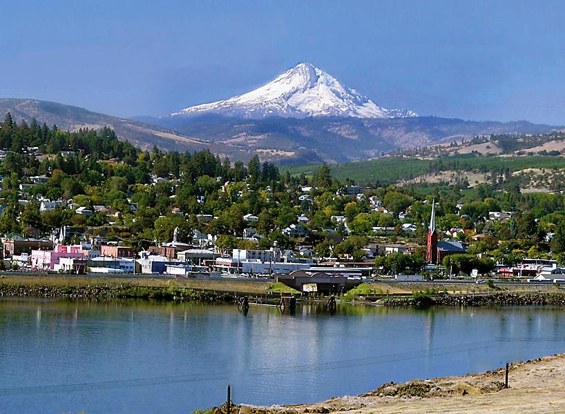
Drive slowly on the historic Columbia River Highway along U.S. 30 and enjoy the stunning waterfalls along the way, and the Vista House at Crown Point State Park, 720 feet above the river. Continue east to Hood River to the History Museum of Hood River, before taking a scenic ride on the Mount Hood Railroad.
From Hood River, I-84 parallels the river gorge to the historic city, The Dalles. Visitors should not miss the Columbia Gorge Discovery Center and Museum nor The Dalles Dam Visitor Center. Nearby, a historical marker tells the story of Celilo Falls and the ancient Indian fishing grounds that were flooded by the Dalles Dam.
The “Oregon Trail” route from The Dalles to Oregon City follows a dramatic segment of the Mt. Hood National Scenic Byway through Barlow Pass, around Mount Hood and through the Cascades to the Willamette Valley.
In Oregon City, the state’s first capital and last stop on the Oregon Trail, you should visit the John McLoughlin House National Historic Site and the Museum of the Oregon Territory. In the city’s Mountain View Cemetery is the gravesite of pioneer explorer Peter Skene Ogden.
As you return to Portland, enjoy the historical markers at the Willamette Falls Scenic Overlook. End your trip at the Bridgeport Brewery and Brew Pub, where you can ponder the eternity of Oregon’s natural beauty and the dramatic history that has shaped Oregon the last 200 years.
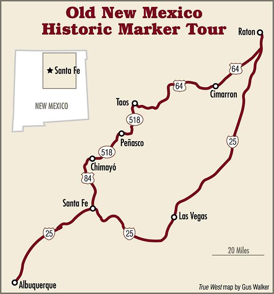
Old New Mexico Historical Markers
Nearly a century after the founding of Santa Fe, the Spanish “founded the new Villa de Albuquerque (now ‘Albuquerque’), which became the principal settlement of the Rio Abajo” along the Rio Grande, an important buffer between the hostile Indians of the south and the capital city to the north. The “Albuquerque” historical marker in “Old Town” will fuel greater interest in learning more local history from historical markers while walking the historic district of the “Duke City.”
North to Santa Fe, a destination since 1609, take the Highway 14 exit and stop at the “Santa Fe” historical marker for a short history lesson on the city. Start your tour of the capital at the New Mexico History Museum and Palace of the Governors. The museum offers daily walking tours of the best historic sites of Santa Fe.
East on I-25, two key stops are the marker for “Glorieta Battlefield,” at exit 299, and the Pecos National Historical Park. The ranger-led guided tours of the pueblo ruins and the Civil War battlefield provide an excellent perspective on the history of the region.
In Las Vegas, visitors will enjoy the Santa Fe Trail Interpretive Center and the City of Las Vegas Museum, with its Teddy Roosevelt Rough Riders’ collection. As you drive north, exit at milepost 360 for the “Fort Union National Monument” marker. A tour of Fort Union, strategically built where the two routes of the Santa Fe Trail intersect, provides an excellent introduction to frontier army life.
At the northbound rest area at milepost 374 off I-25 is the “Santa Fe Trail” historical marker. The site also includes the Daughters of American Revolution’s century-old stone tablet commemorating the trail. In Raton, the key city on the mountain route of the Santa Fe Trail, visit the Raton Museum and take a walk through the central historic district.
From Raton, scenic U.S. 64 leads to Cimarron. Visit the St. James Hotel, which was at the center of the Colfax County War in the 1870s. Look for a “Santa Fe” marker in the town that is now the gateway to the Boy Scouts’ famed Philmont Ranch.
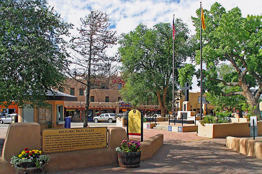
Scenic Highway 64 leads to Taos, where history is as romantic and timeless as Santa Fe’s. Start your tour at Taos Plaza and the “Historic Taos Marker.” Very informative, the marker on the plaza has a map to the central district and a box of free, walking-tour maps of the famed city.
Enjoy the “High Road” to Santa Fe, stopping in the quaint villages of Peñasco and Chimayó. Back in Albuquerque, head down to historic Route 66 and treat yourself to some local fare at the Frontier, where you can begin planning your next trip in search of history in the Land of Enchantment.
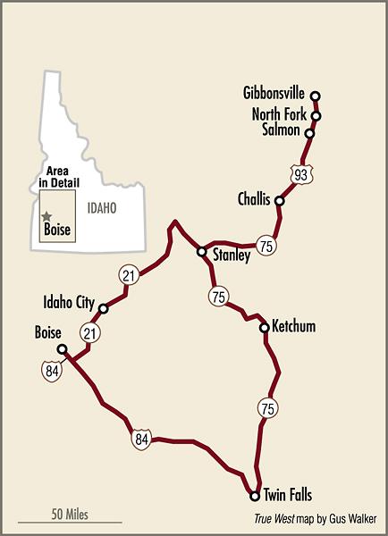
Central Idaho’s Historic Markers
Crossing southern Idaho, Indian tribes, trappers and emigrants on the Oregon Trail all found refuge along the shady banks of the Boise River in Idaho’s Treasure Valley. According to the historical marker at Bonneville Point east of Boise, “a hunting party lead [sic] by the explorer Captain Benjamin Bonneville reached this promontory in 1833. They saw the lush river valley below and exclaimed in French, ‘Les bois; les bois; vouyez le bois!’ (The woods; the woods; see the woods!”) In this way, Captain Bonneville’s party became credited with naming the Boise Valley.”
Leaving modern Boise on Warm Springs Road towards Idaho 21, en route to Idaho City, travel slow to read the numerous historical markers including “Oregon Trail,” “Beaver Dick’s Ferry,” “More’s Creek,” “The Old Toll Road” and “Idaho City.”
After a walk on the boardwalks of the boomtown take a tour of the Boise Basin Historical Museum. The Ponderosa Pine Scenic Byway never disappoints as it twists and turns its way below the jagged peaks of the Sawtooth Mountains. Stanley is a fun rest stop; a tour of the museum at the former ranger station is a good introduction to local history.
From Stanley, the tour enters the Salmon River Scenic Byway, first on Idaho 75, to Sunbeam, Clayton and Land of the Yankee Fork. From Challis to Salmon on U.S. 93, the geography changes dramatically as the highway drops in elevation into the Salmon River Valley. Salmon is home to the Sacajawea Interpretive, Cultural, Educational and Events Center on U.S 93. The “Sacajawea Historic Byway” marker is 1.5 miles southeast on Idaho 28.
Between Salmon and the Montana border are two “Lewis and Clark” markers, one outside of North Fork at milepost 326.1, on the west side of the road, and one at milepost 345 near Gibbonsville, on the east side of the highway before it switchbacks to a Montana welcome center just across the state line.
Doubling back from Salmon, you will want to return on U.S. 93 to Stanley to pick up the Sawtooth Scenic Byway, Idaho 75, to visit Ketchum (Sun Valley), Hailey, Shoshone and Twin Falls. Both Hailey and Ketchum have excellent local museums. In Shoshone, stop at the “Shoshone Historic District” marker, for an introduction to local history.
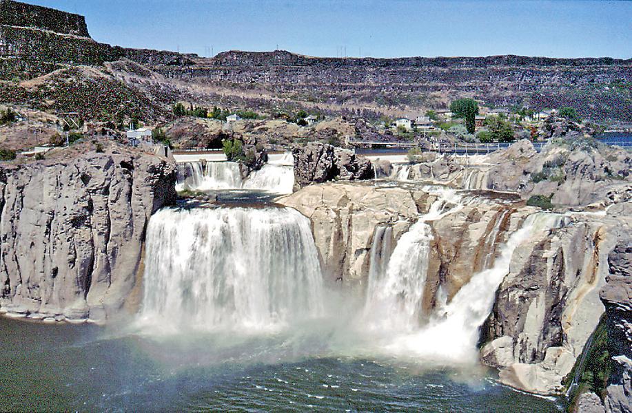
Before you return to Boise, don’t miss Shoshone Falls on the Snake River, one of the most distinctive geological sites in Idaho. In Shoshone Falls Park in Twin Falls is the informative marker “Shoshone Falls: The History of Shoshone Falls Dam.”
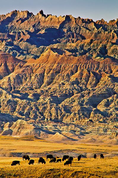
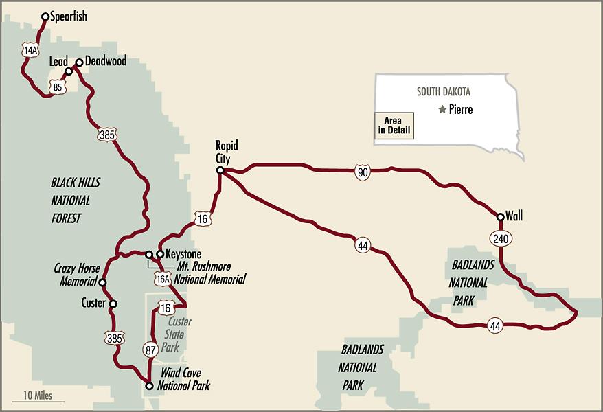
South Dakota’s Black Hills to Badlands Historical Markers
In 1876, gold fever brought miners and bonanza seekers from across the country to the Black Hills. “Buckskin” Johnny Spaulding, a buffalo hunter, followed the fever to the gold camps, where he earned a living supplying game meat to the busy miners. When fear spread across the region after the Battle of Little Big Horn, he helped build the “Custer Stockade” in Spearfish. A historical marker on Spaulding’s Cabin tells his tale at Belle Fourche’s Tri-State Museum.
Leaving Spearfish, take your time driving the twisting and turning back roads of the Black Hills, with its numerous historical markers. Since the discovery of gold in the mountains led to the Great Sioux War of 1876, the Homestake Open Cut Mine marker in Lead on U.S. 85 (West Main Street) is a must stop. Down in Deadwood, visit the Adams Museum and Days of ’76 Museum for an introduction to local history. At the Deadwood History and Information Center, daily bus tours glorify the gold’s camp’s wild past with a pilgrimage to Calamity Jane and Wild Bill Hickok’s graves in the Mount Moriah Cemetery.
From Deadwood, drive U.S. 385 to Hill City, the Crazy Horse Memorial and Custer. Before Hill City, turn on Silver City Road to visit the 1876 mining camp and historical marker tour of the Silver City mining village.
East of Custer, on U.S. Highway 16A, is the state marker: “Campsite of General Custer’s Expedition, August 1-6, 1874.” During his famed Black Hills Expedition, Custer made his encampment here with over 1,000 men, 110 wagons and more than 2,200 head of livestock.
From Custer’s Campsite, key stops include Wind Cave National Park and Mt. Rushmore National Memorial. Nearby, Keystone is a good place to stay while touring the Black Hills, with the Gutzon Borglum Historical Center, Big Thunder Gold Mine Tour and 1880 Steam Train.
Travel north on U.S. 16, a portion of the Peter Norbeck National Scenic Byway, to State Highway 44, the beautiful back road to Badlands National Park and the Badlands Loop Scenic Byway. Travelers should give themselves plenty of time to stop and read the informative markers on the 30-mile loop.
Finish your tour in Rapid City at the “Rapid City Founders Camp Site” historical marker at Halley Park, noting that the city was founded on February 24, 1876. You can see where the pioneers camped just a few blocks away at Founders Park. At the Rapid City Visitor Information Center, you may ask about the local walking tours, including the Presidential Statue Tour in the historic district.
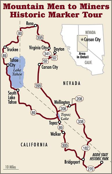
Sierra Nevada Historical Markers
In October 1846, the weary Donner Party, en route to the promised land of California, took refuge near Nevada’s Truckee Meadows, unknowing that the horror of starvation, cannibalism and death awaited them in the distant Sierra Nevada. In humble Donner Party Park in Reno, the “Emigrant-Donner Camp” historical marker, at the base of Rattlesnake Mountain, tells the tale. A few miles away, the historical marker “Junction House,” on South Virginia Street, marks the key gathering place for emigrant wagon trains and the toll roads that converged at the first settlement in the Truckee Valley in 1853.
When you leave Reno, drive west on I-80 to the Truckee, California, exit to view the “Donner Party” historical marker at the Donner Memorial State Park. Nearby, at the Southern Pacific Depot at 70 Donner Pass Road, view the “First Transcontinental Railroad-Truckee” marker, ironic in its proximity to the site of the Donner Party tragedy just 22 years before.
From Truckee, follow scenic California 89 along the western shore of Lake Tahoe to South Lake Tahoe, where the highway leads up and over the mountains to U.S. 395 north of Topaz. Turn south, to Bridgeport and the Bridgeport Inn, founded in 1877, for a good meal and even an overnight stay. Seven miles south, make a stop at “Dog Town 1857” historical marker: “Site of the first major gold rush to California’s eastern slope of the Sierra Nevada.” Continue south and follow the signs to Bodie State Historic Park, where daily tours of the well-preserved, remote mining camp are offered from Memorial Day to Labor Day.
From Bodie, the tour goes north from Bridgeport on California 182 and Nevada 338 through the Humboldt-Toiyabe National Forest to Nevada 208, which reconnects to U.S. 395 north to three places on the National Historic Register: Carson City, Dayton and Virginia City. In Carson City, historical markers await at the Nevada State Capitol and the Nevada State Museum where you can read about the “United States Mint” that opened in 1870 and closed in 1893, but not before minting $49,274,434.30. Continue north from Carson City to Dayton and Virginia City, both rich in pioneer and mining history, and historic sites, restaurants and hotels.
Back in Reno, round out your tour at the National Automobile Museum. If you visit in late February, cruise north on I-80 to enjoy Winnemucca’s week-long, Great Basin buckaroo celebration, the Ranch Hand Rodeo, Nevada’s largest team rodeo competition.
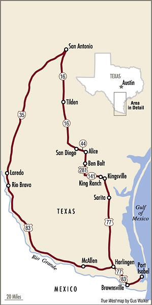
South Texas Missions, Ranches and Rio Grande Markers
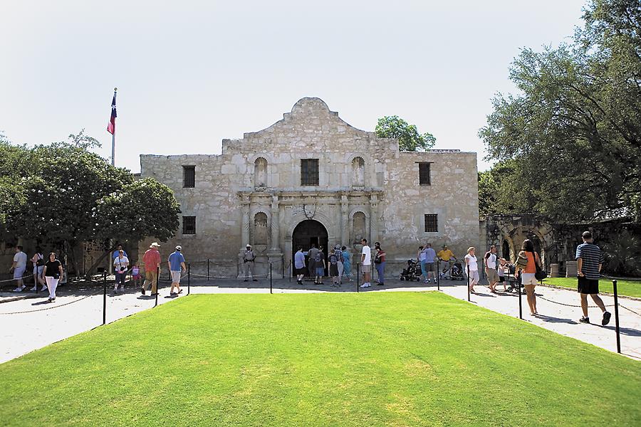
“Thermopylae had its messenger of defeat. The Alamo had none,” declares “The Defense of the Alamo” historical marker at San Antonio’s “Shrine of Texas Liberty.” While you walk the hallowed grounds of the Alamo, take in the Texas state historical markers telling the tale of the famed mission where Davy Crockett, James Bowie and William Travis met their fate at the Battle of the Alamo in February-March 1836.
Driving south on I-35 from San Antonio to Laredo, the traveler enters the “brush country” of South Texas. Two key historical markers on the way that give insights into the region’s history are placed near the courthouses in Pearsall and Cotulla. In Cotulla, stop a half-mile past the Nueces River Bridge on I-35 for “The Nueces River at Texas Boundary” marker, which boldly states, “Until 1836 this river formed the undisputed western boundary of Texas.”
In northwest Laredo, the historical marker on U.S. Highway 83, “Poblacion de Dolores,” declares quite simply: “Oldest Spanish settlement on north bank of Rio Grande. Founded August 22, 1750….” While on the trail of markers in Laredo, tour the San Agustin Plaza, San Agustin Cathedral, La Posada, the Republic of the Rio Grande Museum and Villa Antiqua Heritage Museum.
From Laredo, U.S. 83 is your highway to historical markers along the Rio Grande to Port Isabel. In Brownsville, on E. Elizabeth Street at International Boulevard is “The Chisholm Trail” marker, just one of 14 marking the border town area’s importance to U.S. and Mexican history.
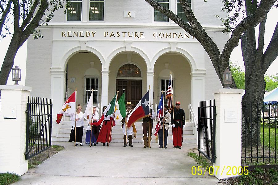
Texas ranching history is the theme of the drive from Port Isabel to San Antonio. In Kenedy County, home to the Armstrong Ranch, stop at the “Armstrong Ranch House” marker. In Sarita, a must stop is the Kenedy Ranch Museum of South Texas. Twenty miles north, 12 historical markers can be seen in or near Kingsville, headquarters for the famed King Ranch and King Ranch Museum.
Circling back to San Antonio, your heritage trail follows a series of blue highways to see historical markers in Alice, Freer and Tilden, including the “San Caja Hill” marker on Texas Highway 16 that recounts the “aftermath of the Turkey Creek Indian Battle.” Finish your trip on the Mission Trail of San Antonio to the Alamo, where, for many, Texas history begins and ends.
Photo Gallery
– By Chad Coppess / Courtesy South Dakota Dept. of Tourism –
– Courtesy TravelNevada –
– Courtesy New Mexico Tourism Dept. –
– Courtesy Sacajawea Center –
– Courtesy Homero S. Vera/Kenedy Memorial Foundation –
– Courtesy Idaho Tourism –
– Courtesy Kenny Braun –
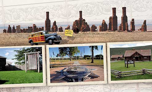
Historical markers await travelers’ curiosity at (clockwise from top): Fort Union National Monument, New Mexico; Stanley Idaho Museum, Idaho; Fort Astoria National Historic Landmark, Oregon; Geographic Center of the United States, Belle Fourche Chamber and Visitor Center/Tri-State Museum, South Dakota; Virginia City Comstock Lode Historical Marker, Nevada.
– Courtesy New Mexico Tourism Dept.; Courtesy Peg Owens; Courtesy Astoria Warrenton Chamber of Commerce; Courtesy South Dakota Dept. of Tourism; Courtesy TravelNevada –
– Courtesy The Dalles Chamber of Commerce –
Related Articles
-
About a decade ago, someone, I think it was Gus “The Mapinator” Walker, noticed that…
-

Berkley: The Gila Wars by Larry D. Sweazy (May); Hell’s Angel by Peter Brandvold (June);…
-
The arrival of the daguerreotype in the…