 John Wesley Powell came to Wyoming’s Green River City in 1869 to launch the first of his two expeditions down the Colorado River.
Earlier, in 1867-68, he had explored overland in western Colorado, searching for the source of the Colorado River. At first, he intended to start his journey at Grand River, the confluence of the Colorado in Utah with Green River. (Since the Grand heads into Colorado, the state successfully renamed this river the Colorado in 1921.)
But when it was time to launch the boats, Powell started on Green River in southern Wyoming. The decision came largely because the Union Pacific Railroad was in the final weeks of its multi-year effort to span the continent, and Powell could easily ship supplies—and the four boats he would use—to the location where the river and the railroad intersected.
Powell gave an interview about his intended expedition to The Chicago Tribune on May 7, 1869, and immediately left for Green River City; just three days later at Promontory, Utah, the golden spike was struck, linking the Union Pacific with the Central Pacific. When Powell arrived at Green River City, he found the 10 members of his Colorado River Exploring Expedition already on hand.
The four boats of the expedition—the Kitty Clyde’s Sister, No Name, Maid of the Canyon and the Emma Dean, the smallest of the crafts and named for Powell’s wife—pushed off from an island on May 24 amid cheers from the crowd that assembled on the river banks.
That island, since called Expedition Island, now a National Historic Landmark, is a public park in Green River with walking paths and interpretive areas. It is in this community still dominated by the Union Pacific Railroad that I begin following the trail of John Wesley Powell. But unlike the one-armed commander of the expedition (he had lost his right arm during the Civil War battle at Shiloh at Pittsburg Landing), I will stick to dry land—roads and highways—rather than taking the journey in a boat.
Disaster in Green River
It is virtually impossible these days to ride the river from Green River to Grand Canyon because of dams constructed to harness the current. All along the route, however, there are still opportunities to get on the water; one can challenge the white water in the Canyon of Lodore or the Grand Canyon itself or one can fish from still water on reservoirs created by the dams.
A statue of Powell stands on the southwest corner of the former Green River Post Office, a building that has been transformed into the Sweetwater County Historical Museum. A white-water park has been created in the Green River itself, where kayakers and rafters hold periodic competitions. Every August, the town pays tribute to the explorer with its Powell Plunge River Festival.
There are two routes south from Green River. Wyoming Highway 530 west of the river is the most scenic with occasional views of the river canyons filled with the backed-up water of the Green that is now Flaming Gorge National Recreation Area; you are likely to see Rocky Mountain Bighorns as you wind your way through the steep country just before reaching the Utah border. On the eastern route—U.S. Highway 191—the landscape is mainly high desert and home to wild horses, but this road takes you right across the dam. The two roads come together in northern Utah and from this point south, I stick to U.S. 191.
The first night out of Green River City, Powell scaled a cliff above the river where he could “look off in every direction over a vast landscape … heights and clouds and mountains and snow fields and forest and rocklands are blended into one grand view.”
At the confluence of Henry’s Fork with the Green, Powell retrieved provisions and instruments he had cached there the previous year, then he and his crew floated into the canyon they called Flaming Gorge (now a part of the national recreation area). Today the river has disappeared into the larger reservoir, but Powell and his men bounced over white water like “blacktails jumping the logs.” In places that were too treacherous, they portaged.
South of Flaming Gorge, Powell saw scratched onto a rock wall the name “Ashley, 1825.” He did not know who had made the mark, but later learned it was William Henry Ashley, who crossed near here that year to hold his first mountain man rendezvous organized on the Black’s Fork of the Green, farther to the west.
The Green rolls south along the Utah-Colorado border, meandering lazily at times and crashing against rocks and canyon walls in other places. Powell floated across Browns Hole (he called it Browns Park and the name stuck) and into the canyon he called Lodore, named for Robert Southey’s poem “The Cataract of Lodore.” Here, Powell’s party encountered its first disaster.
The crew in No Name missed a signal from Powell and plunged into the canyon. They dropped over a short waterfall, smacked a rock, cracked their boat in two and were tossed into the raging river. Although the men survived, their boat, and the supplies and scientific instruments in it, did not. They lost guns and maps, notes from their trip so far and all of the clothing they had brought except what they were wearing. It was the first of many dangerous, potentially deadly, incidents they would face as they journeyed from Green River to the Grand Canyon.
Slot Canyons in Arizona
Taking the land route, I head to Vernal, Utah, and then south toward Moab where I explore Arches National Park, a place Powell and his men saw from the Green River. Their boats swept through the canyons of Utah: Desolation, Gray, Labyrinth, Stillwater and Glen.
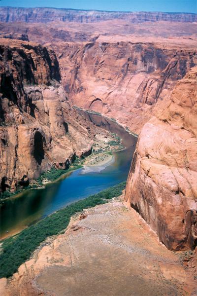
I make my way south on U.S. 191 from Moab, east on U.S. 160 to Kayenta, Arizona, and north on Arizona Highway 98 to Page, Arizona, a city spawned by construction of the Glen Canyon Dam and nurtured by the water recreation associated with the subsequent Glen Canyon National Recreation Area.
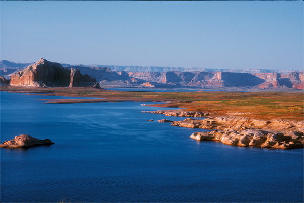
Drought in the West has changed this area significantly since the first time I saw it in the 1990s. Now the white calcium streak representing the high water line is far above the reservoir level. While this may be a concern for boaters and recreational users, I find it fascinating to see areas that were pristine when Powell floated through. They were underwater when I first came here and now are exposed once again.
The region borders the Navajo Reservation, and tribal members have established a boat dock on the south side of the reservoir. The dock complements the long-established facilities at Wahweap, where you can rent power boats or houseboats, or book a leisurely scenic cruise.
The John Wesley Powell Memorial Museum in Page has a replica of the Emma Dean and dioramas depicting Powell’s river journey, along with paleontology displays of the region.
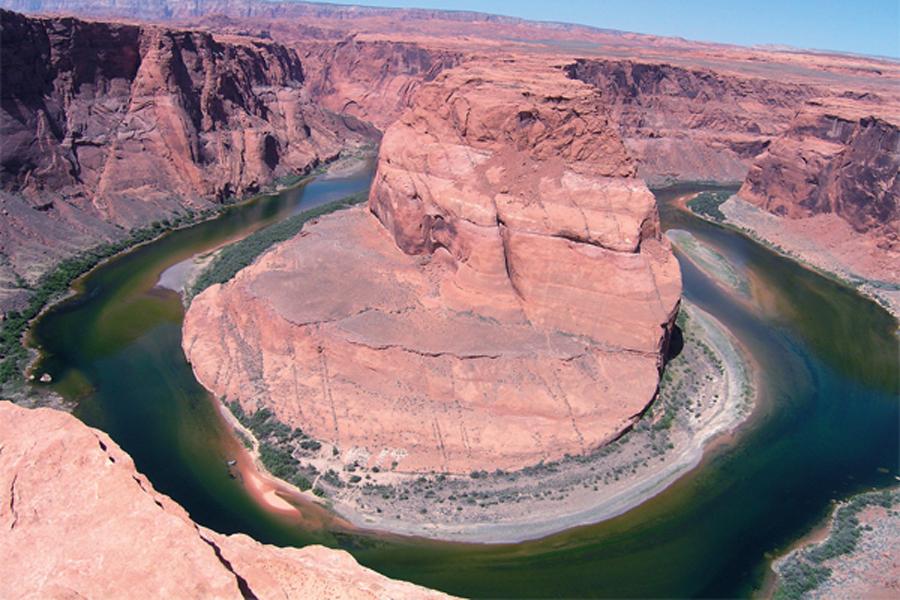
Just as Powell explored canyons along his route, I take the chance to visit slot canyons near Page. The most famous and well known is Antelope Canyon, where sunlight barely filters into the narrow confine. But nearby Canyon X is equally impressive, if more difficult to access, because you must descend a steep rocky area to reach it (and climb that same steep terrain to depart). Harley Klemme of Overland Canyon Tours has exclusive access to Canyon X since the land surrounding it is under grazing lease to his aunt. Horseshoe Bend, just downstream from Page, is one of the most recognized features on the Colorado River, appearing like a cone of rock surrounded by the river as it snakes toward the Pacific.
From Glen Canyon and Page, I travel south and west to Lee’s Ferry, the vital 19th-century river crossing, home to John D. Lee (of Mountain Meadows Massacre infamy) and major launch point today for dozens upon dozens of river rafts taking tourists down the Colorado and into the Grand Canyon.
Powell was here on August 13, 1869, “ready to start our way down the Great Unknown.” They were in northern Arizona, prepared to enter the depths of the Grand Canyon. Powell wrote, “We are three quarters of a mile in the depths of the earth, and the great river shrinks into insignificance as it dashes its angry waves against the walls and cliffs that rise to the world above…. We have an unknown distance yet to run, an unknown river to explore.”
Best way to see the Grand Canyon?
Purists would say you must get on a boat and see the Grand Canyon as Powell did, but for those (like me) who dislike boats and water, there are other options: consider a mule ride or a hike to the bottom of the canyon, or a helicopter overflight that gives you a quick means of exploration. From above, you will see the color of the water diffuse as tributaries join the Colorado and the changing terrain as the canyon widens in places and constricts in other areas.
By traveling highways, you can view the Grand Canyon from its North Rim (where you will find fewer people) or from the South Rim (with its spectacular vantage points). Just the drive from Page to Grand Canyon is stunning. Taking the route to North Rim over the Kaibab Plateau (U.S. 89 Alternate) also gives you a view of Vermillion Cliffs and Marble Canyon; the road to South Rim (U.S. 89 south to Cameron, then Arizona 64 west to the Canyon) takes you through the northern section of the Kaibab National Forest—the largest Ponderosa pine forest in Arizona.
As they neared the south end of Grand Canyon, Powell’s party split. Some of the men left the river, climbed out of the canyon and continued overland, where they were attacked and killed by raiding Indians. The remainder, now too few to man all three boats, abandoned the Emma Dean. The following day—after two weeks within its confines—they broke free of the canyon and entered the Grand Wash.
Continuing on, they rode their boats to the confluence of the Virgin River, arriving there on August 30 and being greeted by Mormon settlers 69 days after they had pushed their boats into the water at Green River City. Powell and his most loyal companions had successfully explored the mighty Colorado River from Green River to Grand Canyon and lived to tell about it.
Photo Gallery
– By Terry A. Del Bene –


